Do you plan to repair septic tanks, set structural foundations, or other projects involving excavation and digging? If so, you need service and utility locating because carelessly digging may cause accidents and cost more than your initial budget plan and set schedule.
Utility and service locating was only required in construction projects in the 1980s. Before, projects were conducted without consideration of underground utilities, resulting in hazardous situations, and highlighted the need for ways to find and map subsurface services.
Here’s everything you need to know about this construction industry standard:
What is Utility and Service Locating?
Utility and service locating is the procedure of finding, mapping, and labelling public utility services like underground electricity cables, pipes, and telecommunication lines.
Engineering and surveying companies conduct subsurface utility investigations using innovative devices and equipment, mapping located underground services precisely.
Here are some common underground assets:
- Water pipes
- Telecommunication services
- Electricity cables
- Gas pipes
- Drainage and sewer networks
- Traffic light circuits
- Storm and flood drains
Why is Utility and Service Locating Important?
Accidentally ruining underground utilities and services may cost you thousands of dollars in fines, compensations, and repair expenses. Moreover, damaging and exposing subsurface assets like electricity cables and gas pipes may pose health and safety risks, not to mention potential projectandservice disruption.
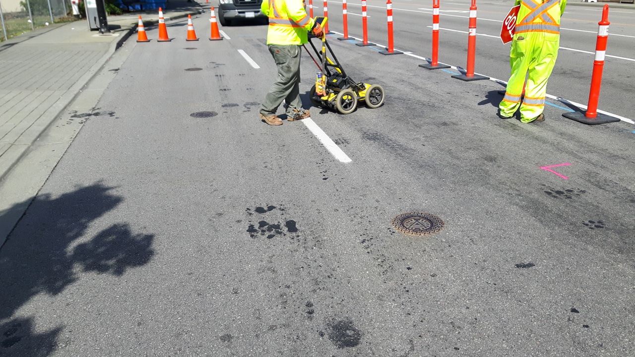
What are Some Utility and Service Locating Methods?
- Electromagnetic (EM) Detection- Metallic and conductive subsurface assets, such as pipes and electrical cables, can be located using the electromagnetic detecting method. The only downside of solely relying on EM detectors is their inability to detect other non-metal underground utilities.
- Ground Penetrating Radar (GPR) Detection- Another utility and service locating method is using a ground penetrating radar. GPR conquers the limitations of EM detection by emitting energy waves and using the reflected signal to locate subsurface assets, even non-metal ones.
- Other Methods- Some other methods do not use energy and radio waves, such as induction ring clamps, potholing, direct connection, and traceable rodders.
How to Choose an Excellent Locating Service Provider?
Choosing the best civil engineering and surveying service provider will help you finish your projects with accurate and reliable results without compromising safety.
Ensure that your locating service provider employs a team of licensed civil engineers, surveyors, and technicians. Moreover, look out for compliance, certifications, and accreditations like the following:
- Dial Before You Dig (DBYD) certification
- Occupational Health and Safety compliant
- Roads and Maritime Services (RMS) Traffic Control at Work Sites (TCAWS) manual accordant
- National Association of Testing Authorities (NATA) accreditation
Are you looking for an excellent, accredited, certified, compliant locator and surveyor to help locate services and utilities? If so, then Durkin is the one for you!
Contact Durkin today and enjoy state-of-the-art technology and licensed experts, providing high-quality professional engineering and surveying services and unmatched customer services.